| Phander Lake | |
|---|---|
| Nango Chatt | |
 | |
 Phander Lake Location in Gilgit Baltistan  Phander Lake Phander Lake (Pakistan) | |
| Location | Phander, Gupis-Yasin District, Gilgit–Baltistan |
| Coordinates | 36°10′23″N 72°56′48″E / 36.17306°N 72.94667°E |
| Type | lake, reservoir |
| Primary inflows | Ghizer River |
| Basin countries | Pakistan |
| Max. length | 900 m (3,000 ft) |
| Max. width | 460 m (1,510 ft) |
| Surface area | 40 acres (16 ha) |
| Max. depth | 44 m (144 ft) |
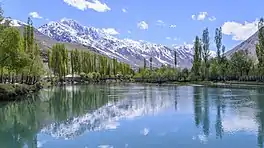
Phander Lake is situated in the Phander Village, in Koh-i-Ghizer, Gupis-Yasin District, the westernmost part of the Gilgit–Baltistan region and northernmost territory of Pakistan. This lake is an important source of fresh water.
Location

Phunder Lake in Gupis-Yasin
Phander Lake is a lake and is located in Koh-i-Ghizer of Gupis-Yasin, a district of Gilgit-Baltistan. Also, the lake is called Nango Chatt. This lake is about to 44 meters (144 ft) deep, in which huge trees are clearly seen.[1][2]
See also
References
- ↑ "Phander Lake in Gilgit Baltistan, Pakistan | iExplorePakistan.com". www.iexplorepakistan.com. Archived from the original on 2010-10-13.
- ↑ http://pk.geoview.info/phander_lake,1552287p
External links
![]() Media related to Phander Lake at Wikimedia Commons
Media related to Phander Lake at Wikimedia Commons
- http://www.iexplorepakistan.com/phander-lake
- http://pk.geoview.info/phander_lake,1552287p
- http://myghizermylife.blogspot.com/
- http://myphander.com Archived 2020-10-30 at the Wayback Machine
This article is issued from Wikipedia. The text is licensed under Creative Commons - Attribution - Sharealike. Additional terms may apply for the media files.